Roll-front deposits of the Battle Spring Formation
Primary Minerals:
Uranium
Stage:
Exploration
Current Status:
Permitting and Licensing for 2024 Drill Program
OVERVIEW
The Company controls a significant land position of approximately 25,5000 acres of mineral rights within the western and southwestern parts of the Great Divide Basin. The Cyclone project has good potential for the discovery of uranium deposits that would be amenable to in-situ recovery (ISR) methods and the project is located approximately 45 miles northwest of Rawlins, Wyoming and 15 miles from the Sweetwater Uranium Mill. The project covers approximately 25,500 acres comprising of 1,061 claims totaling 21,220 acres and 7 state leases covering 4,280 acres.
GEOLOGY
The uranium deposits in the basin are hosted in roll-front deposits of the Battle Spring Formation, with a widespread alteration of host sandstones and numerous roll-front uranium deposits associated with altered rocks. Exploration potential is high for the project with drilling required to follow up on historical work and delineate mineralized zones.
PAST EXPLORATION
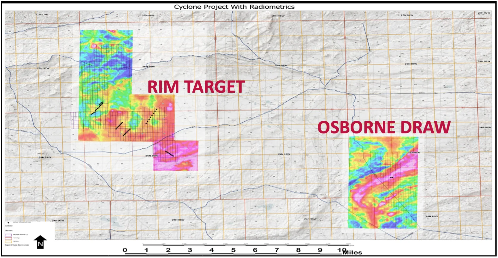
Previous exploration on the project includes ~80 holes drilled during 2007-2008, with mineralization showing typical grades and thicknesses to uranium deposits found elsewhere in the Great Divide Basin. Intersections from exploration on the Rim Target (North claim block) include hole UT-8 which intersected 8.0 ft. averaging 0.092% eU308 (0.02% cut-off) or 5.5 ft. @ 0.121% eU308 at 200 feet from the surface and hole UT-44 which intersected 7.5 ft. averaging 0.081% eU3O8 (0.02% cut-off grade) or 5.5 ft. averaging 0.104% eU308 at a 0.05% cut-off grade.
EXPLORATION TARGET
Sufficient historical exploration data is available for the North and East claim blocks to define an exploration target, which shows a range of 6.5 million short tons averaging 0.06% U3O8 (7.9 million lbs. U3O8) to 10.5 million short tons averaging 0.06% U3O8 (12.6 million lbs. U3O8)1. The potential quantity and grade of this exploration target is conceptual in nature and based on the geologic interpretation that mineralization is roll-front sandstone – type mineralization, and that mineralization is present as indicated by airborne radiometric anomalies, indications of the presence of oxidation reduction interfaces with associated uranium mineralization as depicted in available historic drill data. There has been insufficient exploration to define a mineral resource and it is uncertain if a mineral resource will be delineated. For the definition of the exploration target, the following criteria based on direct knowledge and experience in the area and similar sandstone hosted uranium deposits in the Great Divide Basin and other areas of Wyoming was used: (i) a minimum cut-off grade of 0.02% U3O8 and a grade thickness product (GT) of 0.10, (ii) a radiometric disequilibrium factor of 1, and (iii) a bulk density of 16 cubic feet per ton.
A detailed review of the historical drill data is planned with permitting underway in preparation for drilling in 2024.
Cyclone project with radiometrics
1. As determined by BRS Engineering, sufficient historical exploration data is available for the North and East claim blocks to define an exploration target , which shows a range of 6.5 million short tons averaging 0.06% U3O8 (7.9 million lbs. U3O8) to 10.5 million short tons averaging 0.06% U3O8 (12.6 million lbs. U3O8).1 The potential quantity and grade of this exploration target is conceptual in nature and based on the geologic interpretation that mineralization is Sandstone Type mineralization, aerial radiometric anomalies, and indications of the presence of oxidation reduction interfaces with mineralization from available drill data. There has been insufficient exploration to define a mineral resource and it is uncertain if a mineral resource will be delineated. For the definition of the exploration target, the following criteria based on direct knowledge and experience in the area and similar sandstone hosted uranium deposits in Wyoming was used: (i) a minimum cut-off grade of 0.02% U3O8 and a grade thickness product (GT) of 0.10, (ii) a radiometric disequilibrium factor of 1, and (iii) a bulk density of 16 cubic feet per ton.
DOWNLOADS
Technical Report for Cyclone
SIGN UP FOR UPDATES
Subscribe for the latest updates from Premier American Uranium!